Information
Enable JS (Press red top just in case things went wrong 1st time) and then press Green flag
It takes quite a while to set itself up
At the moment, its best to leave the MQTT option on replay/status as the craft is currently being re-fitted with a new generator back in Plymouth but hopefully it'll be out and about in the next few weeks again
You can use the dropdown menus to select different looking maps - sometimes these take while to load - patience is required
You can use the pan arrows to move the map around but if your in tracking mode - the map will auto-centre again on next data update
To zoom in and out you can either use the buttons or the dropdown
The dropdowns can be a bit slow (depending upon your hardware) as they are all just coded up in Snap!
Once Snap! 7 gets released, I aim to hopefully make my custom costumes reporters into JS extensions that should run a lot faster
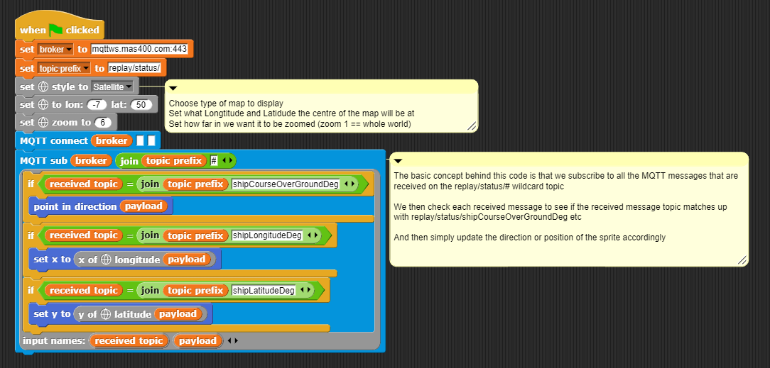
It is supplying data using a protocol called MQTT.
It sends the data over a satellite radio link.
The concept behind MQTT is that you have a program running on a central server somewhere (which is called a broker) and a program running on what's called a client (such as the Mayflower) sending (what is called publishing) messages to it that get stored on the broker.
So its like a simple database in that respect
The clever bit is that a another program (such as my Snap! program) can ask to be updated anytime a new message is received by the broker. This is called subscribing.
Normally a program would have to keep checking the central database to see if records have been updated - in this case, the broker keeps track of who is interested in what information and automatically sends any changes out
Not only is it allowed - it is encouraged by the IBM team behind it
The data is freely available to anyone who wants to use or look at it
Hopefully, later on today, the team are hoping to add the data they collected on detecting sea creatures and I'll be able to popup little graphics of whales and dolphins etc